By Robert L. Reid
In the aftermath of a hurricane or other storm that causes severe flooding in coastal regions, search and rescue teams face considerable obstacles. Streets and other access ways might be underwater or blocked by debris. The exact condition of critical infrastructure — such as levees and flood walls, power plants, pipelines, and water and wastewater treatment plants — might be unknown, posing uncertain levels of risk to first responders, local residents, and anyone else in the area. People might be injured or trapped in buildings that become difficult to find or reach.
During such disaster scenarios, drones provide vital bird’s-eye views of situations, especially the surrounding landscapes or neighborhoods. This can help search and rescue teams find the fastest and most efficient routes to reach people in danger and gather the most accurate data for making real-time decisions that “could save time and lives,” explains Navid Jafari, Ph.D., A.M.ASCE, an associate professor of civil and environmental engineering at Louisiana State University.
Jafari and other researchers from LSU and Texas A&M University have been working with emergency operation centers in Louisiana and Texas on the use of drones to help speed up reconnaissance efforts and information gathering following extreme weather events. Funded by a $180,000 National Science Foundation grant, the project is “looking at how to do a better job of collecting and analyzing data” after a storm, which can still involve sending EOC reconnaissance teams “out into the field to see what happened and then bringing back that information,” Jafari notes.
But the original way of doing this work was plagued by inefficiencies in the collection, analysis, and interpretation of data, especially related to how much time is required for the EOC teams to physically examine large, devastated areas.
This is where the technology comes in, according to Jafari. “Drones can fly over the area and get a better view than even a helicopter,” he explains. Helicopters engaged in such searches generally fly at speeds of 70-80 mph, missing a lot of information. Drones, however, fly much slower, typically less than 10 mph.
Coast Guard training
The work with EOCs has also attracted the attention of the U.S. Coast Guard, which has its own drone program along the Gulf Coast that conducts infrastructure damage assessments or locates pollution or chemical spills after a hurricane. “Our work is another application of the drone, conducting search and rescue,” Jafari says. But it is similar “in that we need to identify and quantify damage but also different in that it requires navigation and communication in a critical environment.”
Last year, the Coast Guard’s New Orleans district invited Jafari to participate in a training exercise that compared how the use of drones could assist in Coast Guard search and rescue operations versus the traditional way such work has been done.
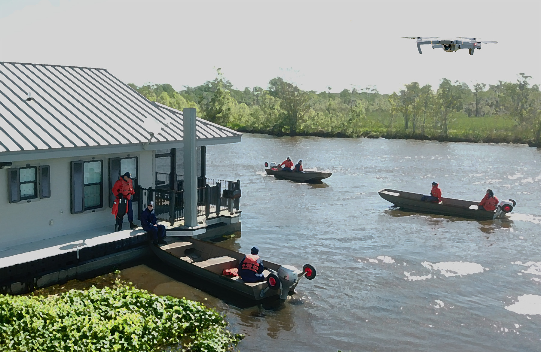
During a week of field exercises, Jafari and his team worked with the Coast Guard at the Bayou Segnette State Park near New Orleans, along a bayou that featured a camp with a series of buildings — representing a neighborhood of homes — located adjacent to the waterway, which simulated flooded streets.
The Coast Guard trainees used small boats to navigate these streets to reach the buildings and then search for dummies that had been placed just outside of or close to the structures. The trainees had to “rescue” the dummies and bring them back.
The first exercise was conducted without drones. Trying to navigate through the bayou, the trainees made a wrong turn that took them away from the intended destination, Jafari says. “So they had to circle back, which lost them a lot of time.”
Once at the camp, they had to weave in and out among the buildings, searching for the dummies to recover, he adds.
Send in the drones
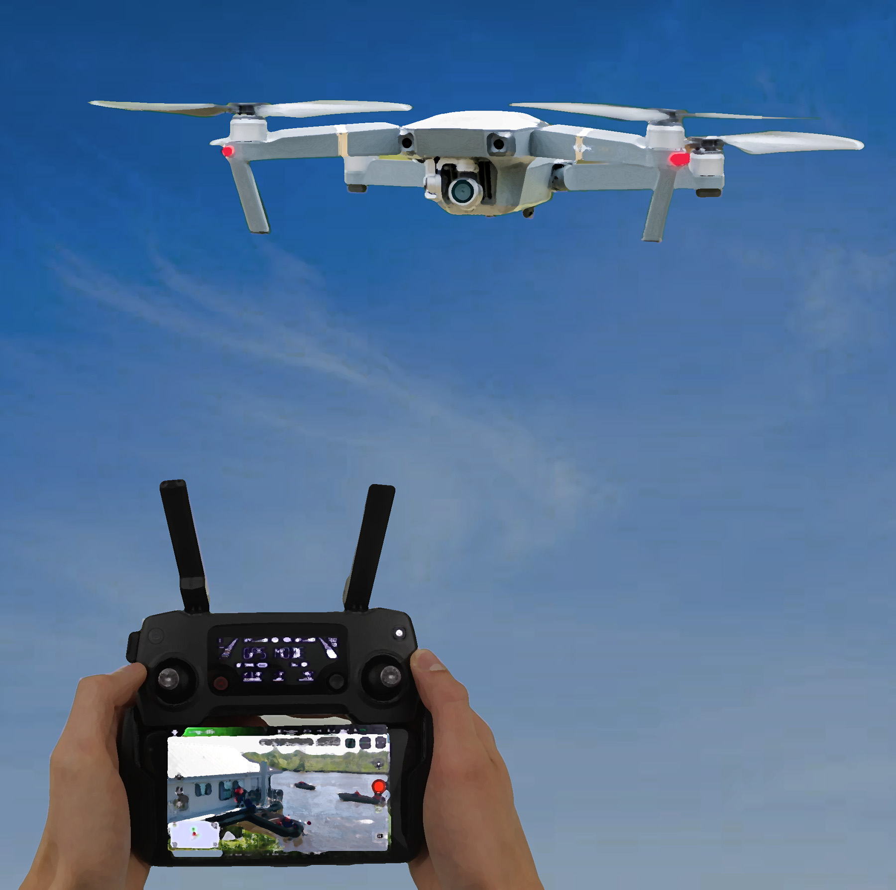
For the next exercise, Jafari’s team used a DJI Mavic Pro drone, manufactured by DJI of Shenzhen, China. The device, which costs roughly $1,000, features a camera to provide aerial images of the areas being overflown, which the drone operator can view in real time. The LSU team sent up the drone before the trainees left the marina. The drone helped “set the course through the bayou,” Jafari says, “and then flew around the buildings to locate where the dummies were.”
The drone then came back to the marina and led the Coast Guard boats through the network of bayous to the campsite and to the specific buildings in which the dummies had been seen.
Although the exercises were not timed, the feedback from the Coast Guard indicated that “it was much better, much easier to have the drone than not to have the drone,” Jafari says. The tests demonstrated the “huge potential” of incorporating low-cost yet effective drones into the Coast Guard’s future search and rescue operations.
Making improvements
The exercises also identified ways to improve the use of the technology. As an LSU researcher operated the drone, a Coast Guard representative stood next to the operator, viewing the live images from the camera and radioing directions to the search and rescue team in the boats.
“But the boat operators didn’t like this because there was too much talking,” Jafari says. Too many other people were also using the radio at the same time for other parts of the exercises, which was distracting. In the future, the boat operators would prefer nonverbal signals. But that posed other challenges because the drones are not very large and can be difficult to see — and therefore difficult to follow — unless they are very close to the boats.
One solution would involve the installation of a series of lights on the drones to convey simple instructions, Jafari says. If a drone was leading boats to a particular destination, a green light could mean “follow me,” a yellow light might mean “slow down, a hazard is ahead,” and a red light could mean “stop!” if the way ahead was blocked, Jafari explains.
Future iterations of the drone system could also include the use of lidar or a multispectral camera that provides infrared imaging. The researchers are also working on new ways to extract information from the images the drones collect. For example, if a drone encounters a stop sign along a flooded street, “you can use that stop sign as a reference of how high the water levels are,” Jafari says.
By watching the water around the sign’s post, “we can also tell them if the water levels are getting shallower or higher,” and that information can be transferred to the search and rescue team. “They (would) need to be careful because there could be a current,” Jafari adds.
Limitations of the drones include how much weight the devices can carry, which relates to how many sensors and of what type; how strong the winds are in the area being searched, with anything faster than about 25 mph making it difficult to control drones; and the battery life, which can provide only about 30 minutes of flying time before the batteries must be replaced.
Looking ahead, Jafari notes that although the recent work with the EOCs and the Coast Guard focused specifically on search and rescue operations in flooded areas, “the work we’re doing is transportable to any disaster: Wildfires, tornadoes, earthquakes, landslides — it’s all applicable.
Robert L. Reid is the senior editor and features manager of Civil Engineering.
This article first appeared in the May/June 2022 issue of Civil Engineering